


![]()
Council Bluffs is Omaha's closest neighbor across the Missouri River. We owe a lot of our existence to Council Bluffs. Council Bluffs is at the western edge of Iowa in Pottawattamie County. The county gets its name from the Pottawattamie (Potawatomi) Native American nation that lived in the area.
Council Bluffs had several names prior to the current one. Early settlers and the Mormon movement contributed to the earlier names.
Early on, the area had no name specifically. The hilly area on both sides of the Missouri River from around the bluffs area near present day Council Bluffs on up the Missouri River was referred to as the Council Bluffs area, the "council" part added as this was the general area that Lewis and Clark had their original council with the natives. Because the Lewis and Clark journals list references to the meeting place as at least three varieties of Council Bluffs spellings, and because the expedition named many locations along the way, it is often reported that the expedition originated the term. The specific area known as current day Council Bluffs was just one of several areas being settled by fur traders along the Missouri. At the time, the Missouri River was the edge of the western part of the United States.
As fur traders became more aware of the "Indian country" west of the Missouri River, they learned of the great Platte River that joined the Missouri to the south (at Plattsmouth). The Platte River swings up to around the same latitude as the settlement that had formed on the eastern side of the river at what is now Council Bluffs. This made current day Council Bluffs area a popular starting point to cross the river and get onto the Platte or follow the trails made along its side by natives, and the buffalo they followed. There were other incentives to join the Platte River at this point rather than to start where it joined the Missouri River. The stretch from the mouth of the Platte River to the area around Bellevue was "occupied" by Native Americans. It was easier to bypass any hassle, keeping both sides content (at the time, the natives didn't have any great animosity toward the lighter-skinned man since the numbers were pretty small).
Following the fur trappers and traders, the first in the (current) Council Bluffs area that qualified as settlers formed a small settlement known as Hart's Bluff. The settlement wasn't large but qualified as a bonafide settlement. Other families settled not far from Hart's Bluff and in several directions. Hart's Bluff was the central meeting place for all of the local residents. It would have developed into an even larger settlement and community, and eventually would have been the major city on the edge of the Missouri River on Iowa's western edge were it not for a sudden influx that for all intents and purposes ended Hart's Bluff forever. A new group showed up and adopted their own name.
The Mormons left their home in Nauvoo, Illinois starting in February 1846, and arrived here in June 1846. The area just south of the main Council Bluffs drag and closer to what is now South Omaha became much more populated when the Mormons arrived. The area soon became known as The Grand Encampment. This is the same location that the first ferry in the area was built after their arrival.
Soon after the Mormons started arriving, the Hart's Bluff area started to be called Miller's Hollow, named after Bishop Henry W. Miller, a Mormon that had settled in the area as one of the first Mormons to arrive here.
A local state representative and friend of the Mormon church, Thomas L. Kane,* was influential to the point that the Mormons started to call the area Kane, and then Kanesville.
The term Council Bluffs is often referred as having been used to describe the surrounding area on both sides of the Missouri River from Ft. Calhoun to Bellevue; the further away from this area, the less defined it was, especially the farther east you went. There is good reason for this, Council Bluffs moved, from one location to the other. Present day Ft. Calhoun area had the name due to the Council Bluffs Indian Agency being located there and later on, Bellevue because the Indian Agency was moved there. At the time of the Indian Agency move, the Bellevue area was known as Trader's Point. After a short time, the Nebraska Post Office established at Trader's Point adopted the name of the Indian Agency. Soon the post office, known as Council Bluffs Post Office became well known, even more so than Trader's Point itself, however, neither Trader's Point, nor Council Bluffs was officially the name of a town.
In 1852, most of the Mormons had moved away from Kanesville. The remaining population decided to have the area surveyed and to adopt a new name. The surveyor A. D. Jones from Glenwood, Iowa suggested the name of Council Bluffs City in order to intercept mail directed to the Council Bluffs Post Office at Trader's Point (Bellevue today). Since neither were official town names, the residents of Kanesville adopted the idea. In January 1853, the City part was dropped when the town was incorporated.
Thus it has been claimed that Council Bluffs stole its name. Regardless, the plan worked as mail was routed to the new Council Bluffs instead of the post office at Trader's Point, advancing the demise of same.
The term Council Bluffs possibly originated from the first meeting between Lewis and Clark and the Oto-Missouri Indians. The August 3, 1804 meeting did not take place in present day Council Bluffs, but was near what is now Ft. Calhoun, although some research has shown that the meeting might be closer to present day Omaha/Council Bluffs.
The term Council Bluffs might have already existed even before Lewis and Clark had their meeting with the natives. Many locations had names already known to the fur trappers that made up part of the expedition. Journal entries referred to the meeting place as "this place is Called Council Bluff," "Our Camp Calld the Council Bluffs" and "Camp Councile Bluff."* The terms may have come from the fact that this place was already established as a meeting place by the natives. Natives had already been meeting with white-skinned French fur trappers and traders, and with other natives. The earliest meeting places were before the earliest trading posts were established. Since fur traders referred to areas on both sides of the Missouri in this area as Council Bluffs, it is not clear that the practice started only after the Lewis and Clark Expedition.
The Mormons first arrived in the area starting in 1846, and settled for a brief period before traveling on, with the majority being the Winter of 1846/1847. Many Mormons moved on to the Great Salt Lake Valley in 1848.
From 1846 to 1853, the area was mostly populated by the Mormons. Even though after 1853 the area was no longer predominantly Mormon, the church members continued to be settled in the surrounding areas as late as 1859 or 1860.
A more extensive coverage of the Mormon's contribution to local history covers the time prior to arrival at the area south of Council Bluffs called Grand Encampment, to the time the majority of church members moved on to the Salt Lake Valley. Check out the Mormon pages
Kanesville Tabernacle. (222 E. Broadway, Council Bluffs, IA (![]() ))
)) ![]()
The Mormons contributed to the history of the Council Bluffs area in many ways. After their leader, Joseph Smith and his brother Hyrum were murdered near Nauvoo (in nearby Carthage, Illinois), the Mormons were ruled by the Quorum of the Twelve, with Brigham Young presiding over the Quorum. As the members moved on from the Grand Encampment area to the Salt Lake area, Mr. Orson Hyde was left to preside over church members in the area. Mr. Hyde was publisher of "The Frontier Guardian" an important pioneer publication.
Even though the leaders (including Brigham) had made it on to the Salt Lake Valley, the largest gathering of church members in the United States was still in the local surrounding area, so Brigham returned after only staying in the Salt Lake Valley area for three weeks in order to help bring the following together and to encourage them to continue the journey.
It was known that the First Presidency would be reinstated and it was clear that Brigham Young would be sustained as the Prophet and President of the Church. On December 5th, 1847, the Quorum of the Twelve met at Orson Hyde's farm home about eight miles southeast of present day Council Bluffs.
A unanimous approval reorganized the First Presidency with Brigham Young as Prophet and President, Heber C. Kinball as First Counselor, and Dr. Willard Richards as Second Counselor. The Quorum of the Twelve Apostles comprised of Brigham Young, Heber C. Kimball, Parley P. Pratt, John Taylor, Wilford Woodruff, George A. Smith, Orson Hyde, Willard Richards, Lyman Wight, Orson Pratt, Amasa Lyman, and Ezra T. Benson. The precedent set in the tabernacle of reorganizing the First Presidency following the death of a Prophet continues today.
Church policy is to sustain the reorganization by church members. Immediately, Bishop Henry W. Miller was assigned the task of building a tabernacle large enough to accommodate a large gathering of the members in order to present and sustain the new First Presidency. A log tabernacle was built in the near downtown area of current day Council Bluffs, and the gathering occurred on December 27th, 1847. This means that Bishop Miller had to build the 60' x 40' tabernacle in approximately 18 days. This allowed him 2 or 3 days to gather 200 men to complete the monumental task in a cold and bitter December. The building would need to accommodate 800 to 1,000 people, and was packed when at least 1,000 showed up.
Following the General Conference of December 27th, the newly reorganized First Presidency was sustained in the tabernacle again during the General Conference of the church that convened on April 6, 1848. In Manchester, England, 18,000 members sustained the reorganized First Presidency in twenty-eight conferences on August 14, 1848. Another 5,000 members in Salt Lake Valley sustained the brethren on October 8, 1848.
It was learned later that the log tabernacle was built on ground that had an underground natural spring, so when the grounds thawed, the bottom logs became water-logged and started to rot. The tabernacle continued to be used for two or three years at which time the bottom logs were heavily damaged. Having served its purpose, the good logs were salvaged leaving the remains to deteriorate.
After the Mormons moved on, the tabernacle and its important contribution to the saints existed only in history records. In 1996, an authentic replica of the tabernacle was built on as close an area as currently possible.*
You can visit the tabernacle and visitor center April through September, open 9:00 A.M. to 7:00 P.M. and October through March, 10:00 A.M. to 5:00 P.M. The tabernacle is closed on Christmas. Admission is free. The tour is sponsored by Kanesville Restoration, Inc. and Pottawattamie County Historic Trails Association, Inc., both non-profit organizations. As you can guess, the tour is worth a lot more than "free" so carry some change with you. All donations are tax free, receipts provided. You may contact the center at 712-322-0500.
We also have the Hyde Park area to commemorate these early contributors to the rich history of the area.
More on the early Mormon story.
General Dodge House. (605 Third Street, Council Bluffs, IA (![]() ))
)) ![]()
The General Dodge House is the preserved and restored home of General Grenville M. Dodge from the Civil War era. Gen. Dodge was also a railroad engineer and banker following the Civil War. He settled at the frontier to the west where his experience was applied to grow the new west. Gen. Dodge was known to be the best railroad builder in the land. He is largely responsible for why we are here instead of further up or down the Missouri River. Bringing the railroad through Council Bluffs and Omaha helped the area prosper greatly in comparison to other well established communities on the Missouri.
The 14 room house was built in 1869 in the Victorian fashion. Some of the original furnishings are still in the home. You should visit the home at two different times of the year. During the summer months, the grounds are beautifully decorated with flowering color, peaking during the annual garden walk. During December, the home and grounds are decorated for Christmas with Christmas trees of all sizes everywhere you look. Don't miss either tour. The house is open for viewing 10 A.M. to 5 P.M. Tuesday through Saturday, and 1 P.M. to 5 P.M. Sunday. 712-322-2406
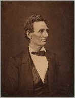
Council Bluffs has a beautiful cemetery overlooking the Missouri River up on the bluffs just above the city. If you haven't yet visited this cemetery, you should. The cemetery dates from the Mormon era with several early Mormon pioneers buried here. The cemetery was also known as the Kanesville Mormon Cemetery. In 1963, the cemetery was renamed to Fairview Cemetery. In 1974, the cemetery was given to the city of Council Bluffs. This is the cemetery that has the famous "Black Angel" that has created an urban legend of predicted future death.* The angel is actually a beautiful memorial (called the Ruth Ann Dodge Memorial) that a family made to their mother. Too bad others came along and created the legend, it should not detract from the thoughtfulness of the family. The memorial was created by sculptor Daniel Chester French, who also sculpted the statue of Lincoln* at the Lincoln Memorial in Washington, D.C. Ruth Ann Dodge was the wife of General Grenville M. Dodge, the man who built the railroad from Omaha to the west.
The Civil War memorial at the west end of the cemetery at the very edge of the bluff's top honors Colonel William Kinsman, commander of the 23rd Iowa Volunteer Infantry Regiment, and other veterans of the Civil War.
To locate the cemetery can be an exercise in itself. Council Bluffs' main East-West street leading to and from the Missouri River and downtown Omaha is West Broadway. Locate the North and South 8th Street and go North to Avenue G, then one more block. The next block north would normally be called Avenue H, except it is Oakland Dr. Turn right and look for the entrance (Lafayette Avenue). At the top, Lafayette Ave turns into 2nd Street. You can also start at the bottom of 2nd Street if you are coming from downtown Council Bluffs. Either way, you must start at the bottom of a long hill, so the cemetery is not visible until you reach the top. You will be traveling through an older housing area on your way up, so old, that many houses are now occupied with new generations with small children The road is curvy, so proceed with extreme caution, and be very respectful of the area residents. The area cannot accommodate large flows of traffic.
The cemetery has a great view of Council Bluffs and some parts of Omaha. "Fairview," is an understatement.
The road (Lafayette Ave.) to get to the top of the bluff to see the Fairview Cemetery has a pull-over spot commemorating the visit to the area by Abraham Lincoln in 1859. Overlooking the bluffs to the West, he chose this place to be the eastern terminus of the western half of the first transcontinental railroad. The pylon was erected in 1911 to commemorate the event. To ensure you can read the plaque, make sure you read it on your way up if you plan on staying for the sunset.
From the Lincoln Monument, you are so far up, you can see to the far western edges of Omaha. Try to visit the area and end your visit at the Lincoln Monument around sunset* if you want to see something spectacular. When we have our fantastic "red clouds at night" evenings, you can't help but snap off a roll of film.
Abraham Lincoln also visited the area in 1848 and met with Henry W. Miller, later a civil war veteran, and the early Mormon that gave the area its second name, Miller's Hollow.
Union Pacific Railroad Museum. (200 Pearl Street, Council Bluffs, IA (![]() ))
)) ![]()
The Union Pacific Railroad Museum outgrew its former location in the Union Pacific Headquarters building in Omaha, so they restored the old downtown library building. They have created an impressive collection of historic artifacts that are associated with railroad history in the area. Union Pacific.
Western Historical Trails Center. (3434 Richard Downing Ave., Council Bluffs, IA (![]() ))
)) ![]()
If you would like to see some more of Council Bluffs rich history, stop by the Western Historical Trails Center. They have an exhibit center, and also provide tours and even hikes to the Missouri since they are only a half mile away. You can contact the center by phone at 712-366-4900 or on the web by clicking here.
Squirrel Cage Jail. (226 Pearl Street, Council Bluffs, IA (![]() ))
)) ![]()
Downtown Council Bluffs has an interesting bit of history with the squirrel cage jail. The jail was made to rotate so that guards could have a continued look at all prisoners as they rotated by. I would think it would be successful in curbing public drunkenness. Imagine spending a night in that jail! The three story jail allows access to only one jail cell at a time. The jail was built in 1885 and remained in use as late as 1969. The design is not totally unique, however, it is the largest of its type still in existence. The jail is a popular tourist attraction. It is located in front of the Pottawattamie County Courthouse. You can tour the jail Tuesday through Saturday, 10 A.M. to 4 P.M., and Sunday, 1 P.M.-4 P.M. Admission is $7, children aged 6-12, $5 (under 5 are free). 712-323-2509
Theatre. ![]()
![]()
Council Bluffs is home for Chanticleer Community Theatre, one of the longest existing theatres in the area.
Modern Day. ![]()
![]()
Council Bluffs is in the process of updating its appearance with a new theme that carries its historical perspective into the future. Along the entry way into Council Bluffs from Omaha (West Broadway), the area recently had a new facelift.
Four new columns went up, two per side. These columns have a curved top that reflects light back down on Broadway. The sides of the columns have subdued colored lighting behind frosted glass. The columns are modern updates of a past generation neighborhood marker that can be found in nearby neighborhoods. The curved light reflector theme will be carried into light poles along Broadway leading traffic into downtown Council Bluffs. At the viaduct, two more towers will be added to help carry the theme into downtown. Downtown will get a bit of facelift to continue the theme around the water fountain. Expect to see new trees and shrubbery all along Broadway to liven things up a bit.
Downtown Council Bluffs streets have already been through a facelift a few years back. Several corners have historic mosaics detailing some part of Council Bluffs history. Street edges have a checkerboard design that can also be seen as the theme for the Council Bluffs Chamber of Commerce website.
Council Bluffs brought greyhound dog racing to the area in the early 80s at Bluffs Run. Riverboats allowing gambling were added in the mid 90s. Along with the gambling boats, Council Bluffs has two gambling casinos, the Ameristar and Harrah's. The tax dollars generated have funded a very modern library for the area.
For some reason, Council Bluffs has an unusually large population of black squirrels. They have become the city's mascot of sorts. The squirrels are protected to further guarantee they will be around for future generations. If you haven't witnessed this unusual bit of nature, stop in at any local Council Bluffs park and enjoy the sight. There are a few of the squirrels in Omaha; a good spot to check is Elmwood Park.
Like Omaha, Council Bluffs is limited to expansion by the Missouri River. Council Bluffs has grown, maybe not quite as fast as Omaha has grown, but has made up for it in the 90s.
Interstate 80 swings down from the Northeastern edge and then passes through the Southern edge of Council Bluffs. The I-680 bypass continues west from the dividing point and travels on west to the Mormon Bridge in northern Omaha. Along the Missouri River, runs Interstate-29. I-29 joins in with I-80 along the Southern edge and branches off to the south near 24th street. Therefore, like Omaha, Council Bluffs is bounded by the Interstate system allowing easy travel around its perimeter.
In the late 80s, a large shopping center was built on the far eastern edge of Council Bluffs next to the portion of I-80 that swings down. The easy I-80 journey to visit the new mall brought exposure to the area, and has helped the area grow at a faster pace than normal.
Also near the junction point of I-680 and I-80 is the Iowa Western Community College. The campus has become an important contributor to the area. They have one of the most successful college radio stations in the country (89.7, The River), with an audience far exceeding what many very successful commercial stations wish for.
Council Bluffs neighbors are many due to the 80 to 100 settlements formed by the Mormons in a 30 mile radius of the surrounding areas. Most are smaller farming communities.
The next major city to the east of Council Bluffs is Des Moines, the capitol. Ames is to the Northeast. Clarinda is to the South, slightly east of the city. Council Bluffs' closest neighbor is Omaha, across the Missouri river.
On the Iowa side, the closest neighbor to Council Bluffs is Carter Lake, Iowa near the Eppley Airfield in Omaha. The most common route between downtown Omaha and the Eppley Airfield is through a portion of Carter Lake, Iowa. At one time, the area was on the eastern side of the Missouri River but Corp. of Engineers changed the river's flow to take a short cut, and as a result, cut Carter Lake off from being connected to the rest of Iowa by soil alone. What remains is a large lake named, what else, Carter Lake.
The next nearest neighbor for Council Bluffs is Crescent, Iowa, just a bit north of the city. A portion of the bluffs in Crescent have been turned into ski slopes. Why drive to Colorado when you want to accomplish some around-the-house chores on the same weekend?
On your way to the ski slopes, you pass the Pink Poodle. The Pink Poodle you ask? The Pink Poodle is a must-do restaurant. The owners have a collection of dolls around the edge so you get a free museum visit included. The Pink Poodle is most famous for having a Prime Rib dinner that many just can't consume, it is enormous! So if you think you have had the best and the largest, you better stop by and be able to back up your claim with true bragging rights. Caution, eat only salads for a week prior and following if you are concerned about your heart!
The next nearest neighbor for Council Bluffs is Missouri Valley, Iowa, a tiny bit north of Crescent. There are plenty of reasons to travel to Missouri Valley for true back to life living, affordable real-estate is a major one drawing Omaha and Council Bluffs young adults to the community.
Missouri Valley has an additional asset that gets temporary visitors each fall and spring, the DeSoto National Wildlife Refuge. The visitors number into the hundreds of thousands if you include the snow geese that make this a favorite stopping place during their annual migration.
Blair, Nebraska and Missouri Valley, Iowa claim DeSoto National Wildlife Refuge, however, Iowa gets true credit. The DeSoto National Wildlife Refuge is closer to Highway 73/75 between Ft. Calhoun and Blair. In the fall, you can see thousands of geese at one time as they migrate south for the winter months. The refuge is open for boating, hiking, and picnicking. DeSoto National Wildlife Refuge Visitor's Center has ongoing programs of education, some with guided tours. The steamboat Bertrand excavation has produced several artifacts on display at the visitor's center. 712-642-4121
DeSoto National Wildlife Refuge (1434 316th Lane (![]() ).)
).)